
| Technology for research under the ocean floor | |
| Side Scan Sonar to explore the geology of the seabed | |
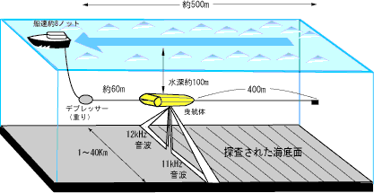
| The bottom of the sea is a dark world where light is not reached mostly. Even though using a powerful light source, attenuation of light is large in the sea, you will not be able to illuminate far. However, by using sound waves instead of light, it is possible to illuminate the appearance of the seabed. Side-scan sonar is a marine remote sensing system to explore the seafloor using ultrasound like as satellite photos. By precisely processing and analysis of acoustic survey data obtained by the side-scan sonar, fine terrain information of the seafloor, especially the seabed geology, can be provided. The side-scan sonar is used for exploration of the geology of the seafloor. While observation, a research vessel tow a machine called a towing body as shown in the figure below. The Towing body send out the sound waves that are spread in a fan shape with the frequency of 10 kHz ~ 500 kHz toward the seafloor. The Towing body then receives the sound waves that are scattered on the sea floor and returned.
|
|
 |
|
|
The strength of the waves that are returned from the seabed surface reflects the "geology" of the seafloor. For example, such as craggy lava, where sound waves are largely scattered and then strongly rebounded. Otherwise, flat mud, where sound waves are slightly scattered, does not make sound waves reflected because sound waves are scattered out. It is the same as that the stone wall repels voices well, whereas the curtain sucks voices. This is the same principle as the scattering phenomenon of light. By displaying the intensity of the sound waves on a recording paper, an acoustic panoramic image of the seafloor can be obtained. |
|
|
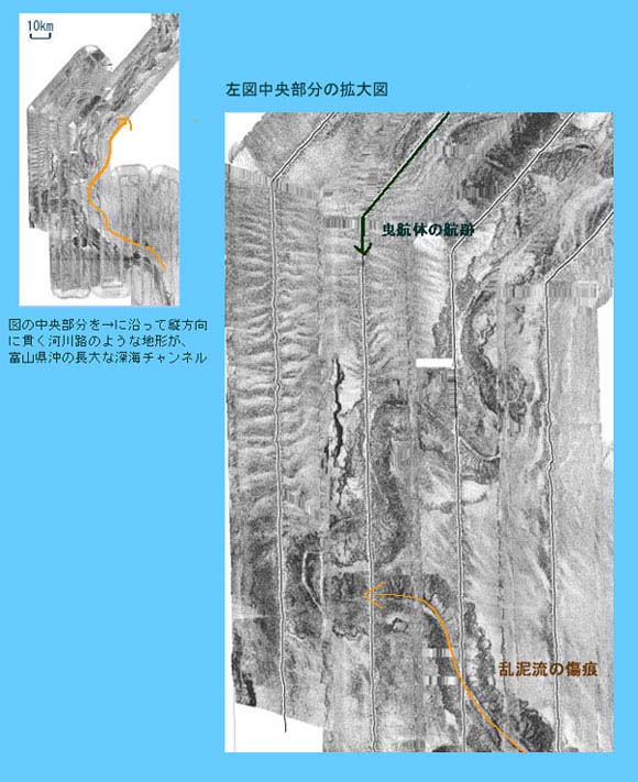
Left: The terrain like a river path that is penetrated in the vertical direction along the central part of the arrow is a long deep-sea channel at Toyama Bay off Right: Enlarged view of the left center |
|
|
The figure above is the acoustic image obtained by a side-scan sonar (Izanagi: Atmosphere and Ocean Research Institute, The University of Tokyo owned). The image obtained from a long deep-sea channel (terrain like river path on the seabed) that spread at Toyama Prefecture offshore. This image represents that sediment which is caused by erosion of the Hida Mountains and delivered from rivers such as Jintsu river, were flowed into Toyama Bay with mudflows and carried over 700 km towards the deep sea part of Japan sea along the terrain. In this way, the side-scan sonar is a marine remote sensing equipment to explore the seabed surface by using sound waves and is useful for obtaining fine terrain of the seafloor, especially information about the seabed geology. |
|
■ Products: LampyridEye
We have developed the software series "LampyridEye" which processes and analyzes the exploration data obtained by a side-scan sonar. By radiometric or geometric correction of the recording acoustic data, precise seabed mosaic images can be created.
| Sub-bottom profiler to explore the geological boundary surface under the seabed |
The Sub-bottom profiler is a device used to explore the geological boundary surface under the seabed using sound waves.
From the sub-bottom data, a stratum cross section image of under the seabed can be created and the distribution of infrastructure and deposited layers can be explored.