
| Technology for research on the land |
| What are the Geological Lineaments? |
|
The Geological Lineaments are single or plural linear pattern that appear in satellite images. The Analysis of natural linear structures provides important information to us. Lineament is considered that they reflect geological structure such as faults or fracture zones as well as artificial structures such as railroads and power lines. |
| Technology for finding the Geological Lineaments from satellite images |
|
In order to apply the geological information for a particular purpose, such as resource exploration, it is difficult to analyze the information obtained from the remote sensing image which is limited from the land surface. Using the information of lineament, it is possible to get a direct and indirect information from the fracture of the deep underground and we can estimate relative easily geological spread in wide areas and the dynamics of the entire crust in the region.
|
| Development of Software for Geological Lineaments Analysis |
|
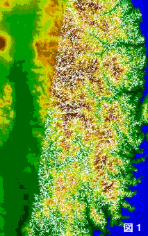
At this moment, the identification of the Geological Lineament requires geologists, well-trained specialists. However, there are problems such as it is difficult to keep the extracted criteria between persons and long terms. Therefore, in the remote sensing, technology to automatically extract and analyze the lineament from the image using a computer is important. The figure above is an example of the image processing the lineaments at the Tohoku, Japan region. The digital terrain model is overlaid on a Landsat image.
|
|
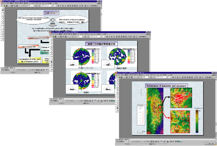
We have been developing a mapping system for lineament classification to propel satellite image analysis. Those are shown above. |
| References |
|
1) Ueki, T., Koike, K., Ichikawa, Y. and Kouda, R., Characterization of Regional Fracture System Through Lineament Analysis Using Satellite Image and Digital Elevation Models of the Land and the Sea Floor.
|