| Technology for research on the ocean | ||
| Water quality analysis at the ocean | ||
|
|
||
| The role of satellite remote sensing | ||
|
It is not visible, but the structure of the ocean has several layers like as the atmosphere. The factors that alter the structure of near sea level are, in large-scale, difference of thermal supply caused by the seasonal variation of solar radiation and , in medium and small-scale, wind, cooling, passage of the vortex, and ocean currents change. These processes vary by ocean area or season and have sometimes constant variation pattern. For the purpose to reveal marine material circulation associated with biological activity, it is important to study processes of mixing and flow in each ocean area and characteristics of biological or chemical processes caused by these processes in the whole ocean area.
|
||
| Development of satellite image analysis software | ||
|
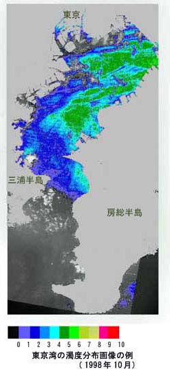
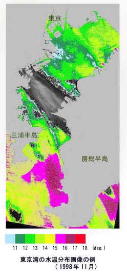
We have been working on and developed a system to analyze satellite picture data automatically and provides water quality of the ocean. We have made accomplishments such as systems to analyze data from LANDSAT, SPOT of France and IRS of India, or ASTER (Advanced Spaceborne Thermal Emission and Reflection Radiometer) sensor and contributed to develop processing algorithms for the analysis of water temperature distribution, turbidity distribution, density distribution of aquatic plants and so on.
|
||
|
||