Sidescan Sonar Data Processing Software
 LampyridEye 8
| About Lampyrid Eye |
| |
LampyridEye8 Catalog (PDF)
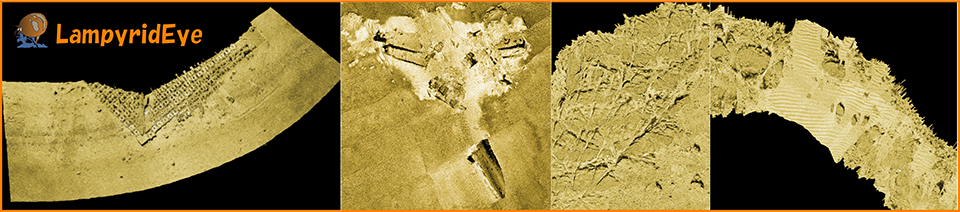
LampyridEye is a software to create mosaic images from acoustic information acquired by side scan sonar.
The optimized user interfaces such as a ribbon bar and a file view improve operational efficiency.
- Supports various side scan data formats
- Visible track editor
- Various correction functions for physical data
- Easy tools to make mosaics
- Displays and outputs high-resolution SSS (Side Scan Sonar) images
|
・Color coding of tracks
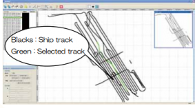
Color coding of tracks (Ship and towfish)
・Radiometric correction
Several corrections are easily executed on the screen.
・SSS images by geometric correction
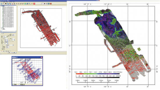
Overlaying color contour on the SSS image
| Main Features of Lampyrid Eye |
| Import File Format |
| |
|
- XTF, XSE, ALL, KMALL, mb41, asd, acf, hsx, scan format.
- Ping file (MarineDiscovery), and other formats (If you have other formats, please contact us.)
- It reads the position information, motion information, and sensor water depth information from an external file, and corrected.
|
| Support SSS Model |
| |
|
- SIS1600, C3D, Seabat8160, SeaBeam series, EM series
|
| Information sharing |
| |
|
|
| Track Correction |
| |
|
- Display of track information. (ship and towfish)
- Manual or Auto editing of track. (linear interpolation, spline interpolation)
|
| Quality Control |
| |
|
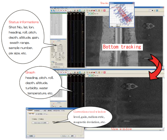
- Browsing of data for each ping. (e.g. date and time, location, 3-axis information, altitude, water depth, gain, pixel size, etc.)
- Graph displays of 3-axis information.
- Various correction for each file. (e.g. level, radiometric, magnetic deviation, bathymetric distortion, etc.)
- Batch Calculation of under water depth for each ping from image.
- New function for cleaning noise (angle filter, add flags for noise)
|
| SSS Image View |
| |
|
- Geometric correction by using motion or track data.
- Method of display image is selectable. (e.g. raw, interpolation, averaging)
- Easy to generate mosaic images. (image display order is selectable e.g. port, starboard, and time axis respectively.)
- Import of contour images. Overlapping of contour images created by MarineDiscovery on mosaic images is available.)
- Display mosaic images with color.
- Distance measurement is available on the mosaic image.
- Importing color palettes files (clr of ESRI and cpt).
|
| Export File Format |
| |
|
Bitmap, GeoTiff, PostScript of Mosaic image
CSV file of latitude, longitude and sound pressure.
GeoTiff of digital number(32bit float).
|
| |
|
|
| Operating environment |
| |
OS |
Windows 10, 11 (64 bit) |
| |
CPU |
6 Core or more |
| |
Memory |
8 GB or more |
| |
Hard Disk |
50 GB or more |
| |
Graphics board |
Supports DirectX 9.0c and above |
| |
Peripherals |
CD-ROM, Keyboard, Mouse |
| |
Screen |
Resolution: 1280×1024 or higher
Number of colors: True Color 32 bit or higher |
LampyridEye8 Catalog (PDF)