
Survey Support Software MitoOshie![]() Sounding Lidar Extension
Sounding Lidar Extension
| Sounding-Lidar Extension ~ Seamless mapping from sea to land ~ |
||
|
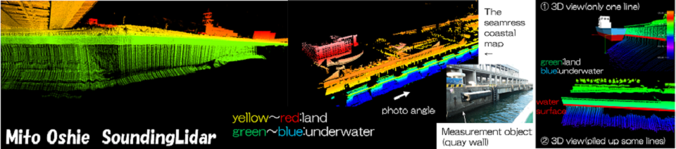
Mito Oshie SoundingLidar Extension Catalog (PDF) Mito Oshie Sounding-Lidar extension can record simultaneously underwater data with multibeam sonar and land data with laser scanner, and display or replay seamlessly as continuous geospatial information. Since seamless point cloud data over the amphibious area can be visually grasped as 3 dimensional geospatial images in real time with recording, it is useful for grasping the situation across both amphibious areas such as port maintenance and river protection maintenance. It can also be used as a marine vessel maneuvering assistant (pilot) who accesses the coastal disaster area from the sea in the event of a disaster. |
||
|
|
||
|
The underwater and the land portion were measured and recorded at the same time by Multibeam Sonar and Laser Scanner.
|
||
| Recorded Data can be processed and analyzed by the MarineDiscovery. | ||
|
1. Three-dimensional point cloud image which processed sound velocity correction, tide level correction, noise elimination by the MarineDiscovery. 2. Three-dimensional point cloud image which processed sound velocity correction, tide level correction, noise elimination by the MarineDiscovery. |
Simultaneous measurement of Multibeam Sonar and Laser Scanner